

Punta Su Mutrucone - Climb the top of Monte Albo
Monte Albo - this is the solitary white mountain giant from Siniscola, stretching from the coast inland with its huge limestone ridge. Motorcyclists will appreciate the deserted corners on the northwestern wall of the limestone massif and hikers can appreciate the lonely hiking trails with beautiful views of northeastern Sardinia.
Start at the forestry office
The starting point of this short hike on Monte Albo is the a href = "https://goo.gl/maps/b9JdwmREu17KWzZFAo" https://goo.gl/maps/b9JdwmREu17KWzZFA . From May to mid-September, snacks and tasty aperitivo plates await tired hikers (and bikers on a stopover) in the Locanda there.
About 2 hours, short, medium-difficult mountain hike, large parts without shade, same way there and back; adequate marking.
About 2 hours, short, medium-difficult mountain hike, large parts without shade, same way there and back; adequate marking.
Great view of the southern Gallura and the hinterland of the Baronia
Only a few meters from Guzzurra there is a downhill road. The path is marked red-white-red with the number 104 and first leads past a lookout point of the forest guard, which oversees a huge area for early forest fire detection in the summer months. The view extends from the hills of Lula and Bitti far over Buddusò, the forests of Onanì and the lonely mountains from Ala 'dei Sardi to the mountains of Monte Nieddu. In the distance you can see the coast of San Teodoro and the island of Tavolara recognize on the horizon.
Uphill through strawberry tree forests
With this panorama in your back, you continue uphill and immediately left at the first fork in the road (signposted Area Picnic / Su Mutrucone 104). The path leads through tall strawberry trees and past dense blackberry hedges along the way. High above us we see the peaks of the mountain ridge of Monte Albo, the path further uphill is clear and cannot be missed. A fence is crossed on a steel ladder and the path initially leads to the left, with a view of a massive rock needle.
... then zigzag and steep uphill
Then the only strenuous part of this hike begins: A gnarled, old holm oak marks the way up. The ascent leads steeply up the mountain in an old landslide in roughly bricked, tight curves. After five minutes of strenuous ascent, you will be rewarded with a surprise.
The plateau at Mutrucone
In front of us is a wide plateau that is completely different from the rest of the landscape. To the south, the just crested mountain ridge of Monte Albo gently slopes down into a plain in which, depending on the season, afodill lilies or tons of yellow holy herb and thistles bloom. In autumn, on the other hand, the plain is littered with dried bushes and shrubs, from which a few heather and yew trees protrude. There is hardly any water here in summer and the small pond of Pozzo Mutucrone has dried up until late in autumn.
On to beautiful views
On the plateau you can rest at one of the picnic areas at more than 1000 meters above sea level, after about 45 minutes of climbing, before the tour continues. First, a dirt road leads over the plateau to the opposite edge, until the sign S'Ena e M. Jana. Here you have the first view of the east side of Monte Albo. Below us lies the wide, deep-cut valley of the rivers Rio Lussurgiu and Rio Siniscola, through which the SS 131 DCN (Nuoro-Olbia) highway passes. The mountains of Monti Remule are on the other side of the valley.
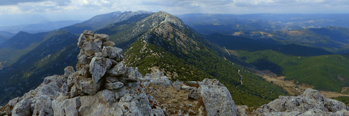
The top of the Monte Albo - Punta Su Mutrucone
We continue diagonally to the right up to the highlight of our hike: The Punta di Mutrucone, which is one of the highest peaks of the approximately 20 km long mountain range of Monte Albo. Here the view is almost limitless. At over a thousand meters above the sea there is an overwhelming panoramic view. It stretches from the dunes of Capo Comino over the valley of Siniscola to the Barbagia , to the west foothills of Monte Albo, north to Ala 'dei Sardi, the ridges of Tavolara Island at the background.
...but at some point you will go back
From here there are two descent options: first, without a path, it goes back a few meters on the way to the top of the mountain and then left down a simple descent back down the mountain slope to a path that leads through a tree heath marked 104B. Hikers with less desire for orientation simply take the exit path back to Cantoniera Guzzurra.
Plan your walking holiday in Sardinia with Sardinia4all!
What is the best accommodation, where is the most beautiful beach, what is the best travel destination on the island for an active holiday? Ask us - we know exactly where to go in Sardinia!
Timo
Sardinia4all
Timo
Sardinia4all


